
Hey Everyone,
And welcome to my very first digital sharing of my journey. Before I get underway, I would like to say thank you. So much love and blessings. I launched this blog officially on Wednesday, and in less than a day people in over 14 countries have taken a peak. I’m greatly humbled and honoured. Thank you again.
Now let’s begin this adventure. So I’m currently in California helping my friend’s parents out on their farm which is tucked away beautifully on a mountain top. I had a couple of days to spare as a majority of work has been completed, so I decided to call my friend Matt who I met in Barbados while he was an exchange student at UWI. We both had some free time, but we were 480 miles from kicking it. We decided to take advantage of this distance and agreed upon a road trip. Over a day and a half he made his way up North to the little town I was in. It was great to see him again, I always find it amazing how friendships don’t weaken over time. We resumed our banter as if we’d seen each other only yesterday. As with usual, we had no idea where we wanted to go. Me, an impulsive non planner, was not bothered by this and anywhere was good enough. Matt, a seasoned planner, wanted to formulate at least a basic guideline so that we could see a lot and he could still be home in time for work.
The difference in decision-making styles would make for an interesting trip, I thought to myself. Checking Google, Matt said that we could drive to and spend a few days at either Lake Tahoe or Big Surr. Each was a little over 250 miles away from our starting point.
Hmm.. Tough decision to make. Lake Tahoe sits at 6,225 feet above sea level, encircled by the Sierra Mountain range while Big Surr, is on the coast, with majestic Redwood forests on one side, and beautiful coastline with beaches, waterfalls and amazing marine life on the other. I mulled it over for a second and made my decision. “Let’s just do both” I said. Matt looked at me with an unimpressed expression on his face. I went on, “Yea b, if we leave now we could drive up to Tahoe tonight, camp and then explore the mountain range for the whole day, drive and camp in Big Surr the same night, then have 2 days to see there. Plus, if we split the driving, it’s only around 2 hours each we’ll be driving a trip.” Matt’s face changed to a smile. This could actually work. I packed my things, said goodbye to my family on the mountain farm, got in the car, Matt started to play an epic electronic set through his car radio, and we departed.
Matt drove the first 2.5 hours before fatigue caught up to him. We pulled over, and he asked me if I had much experience driving on the right hand side of the road. Well, I have driven a bunch in America and a little in Canada. I left out the part where the only driving I’ve done in these countries were off road, where which side you were on mattered not (haha if you’re reading this Bro). He pulled over at the gas station, we switched, I drove out and onto the big four lane highway. “Booom!” 😉 Driving on the right hand side was easy..
What I realised while driving, was that coming from a small island, I underestimated how tiring it was to drive for more than 5 minutes in a straight line. We a droves solid 2 hours before I succumbed to the fatigue. Matt drove the last few miles of the journey.
We arrived in Tahoe City around 11pm. Now we just needed to find a place to stay. We checked google maps and found a campsite close by. On following the GPS directions, we were surprised to see a condominium complex where the camp should’ve been. We searched the only other 2 campsites in Tahoe, but we were met with the same results when we went to them. A somber feeling filled us. The land that the campsites used to be on were much too lucrative to house passing through travellers.
“What should we do now?”
“I guess we just have to check Human Google.”
“What’s that?”
“A conversation. Let’s find a store that’s still open.”
We found a 711 and pulled up. A woman that I reckon was in her sixties was walking out of the store, carrying a bag of garbage. As soon as I saw her long flowing hair and seed of life necklace I knew we had found our informational gateway to an incredible night camping. She looked elated to see us and told us about a hidden beach on the lake close to the first campsite we visited. She guaranteed us that police seldom check that beach for campers so we would have a peaceful event free night.
Guided by her words, we made our way to the beach, the moon was nearly full and high in the sky. We could see how beautiful the area was. We set up our tents and settled down for an peaceful night’s sleep.

In the morning, the sun crept up over the mountain, slowly crossed the lake and then intensely flooded my tent with light. Groggily, I peered out of my tent and was greeted by a palette of colours from the sky, with a beautiful silhouette of the mountain range that encircled the humongous lake. After spending some time taking it all in, Matt woke up, we packed our gear and headed to town to get some breakfast. Matt suggested we check Google to see what the best hike in the area was, but I insisted we instead use Human Google. I was enamoured with the concept of engaging in conversations with real people and learning about an area from their perspective. This technique is what has allowed me to have many unique experiences around the world, but I am typically hesitant to use it in westernised countries. Once gain though, it did not fail us. We were advised of a few spots but the overall recommendation was to go to Blackwood Canyon and hike the mountain there.
As we made our way up the mountain, we passed many trees that only had an intensely bright green moss growing only on one side, which appeared to be facing North. We reached the trail head, got out the car, and was about to begin the hike when Matt paused and said that we were missing a step. “What could that be?” I thought to myself, we already had water and something to eat for lunch. He reached into his pocket, took out two small tabs and gave me one. This couldn’t be what I think it is, right? But it was. Acid. Grooooooovy ….. We touched them together like they were beers then placed them under our tongues. All set and ready.

We began our ascent up in the mountain, the air was fresh, the wind a little chilly. The area was wooded and it was beautiful to observe how the fallen leaves bobbed in the wind, carving a majestic path around the trees. The rustling noise this made lulled me into a meditative state as we climbed the hill.
My mind wandered to thoughts of how the culture of westernisation has spread. I found it in places all over the world that I didn’t expect would be impacted by it. On the flip side, I also noted how the culture of easternisation has also begun to spread across the Western Hemisphere as more and more people begin to search for their routes and a deeper understanding of life.

By now we had ascended to the top of the ridge. The boulders that composed the cliff edge appeared to have been shaped by the wind. The rocks had many different shades and swirls in its many curves and grooves. We could partially see the lake from there, we’d have a much better view once we made it to the peak. We continued our walk along the edge and headed back into the tree line. The moss on these trees made such interesting shapes and patterns that mesmerised us. The effects of the tab were evident. It was amazing to consciously notice the three dimensional aspect of the tree as its angle and appeared changed ever so slightly with every step that I took. There were a few fallen trees that lay over 120 feet long. You know I had to take a run on that. The trees were slightly adjoined to each other so it made for a fun obstacle course.

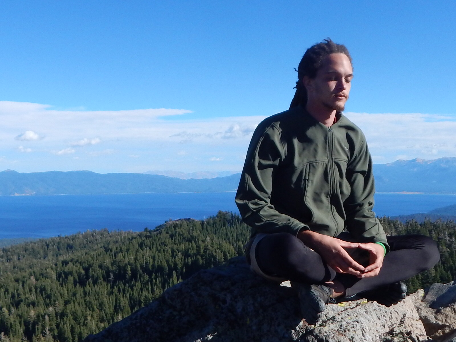
The trees began to thin out as we approached the end of the tree line again. The peak was now ahead of us. The wind was blowing so strong that it was audible. We had to lean into it as we scrambled over the rocks. I kept my gaze towards the ground in front of me right until I reached the top.

Then I looked up, and there it was, Lake Tahoe. It is a 191 square mile body of water. Seeing it from this height blew my mind. See, I was born in Barbados, which is only 166 square mile, so to see a body of water surrounded by land big that is bigger than my island is pretty indescribable. I experienced a similar sensation when I saw lake Turkana in Kenya (2,472 square miles), but I did not get to see it from on top of a mountain like this. This was absolutely breathtaking. Matt and I spent several minutes in complete silence just absorbing the view. From up here the trees looked like blades of grass swaying gently in the wind, and the lake an ultramarine blue mirror reflecting the wispy clouds above them.
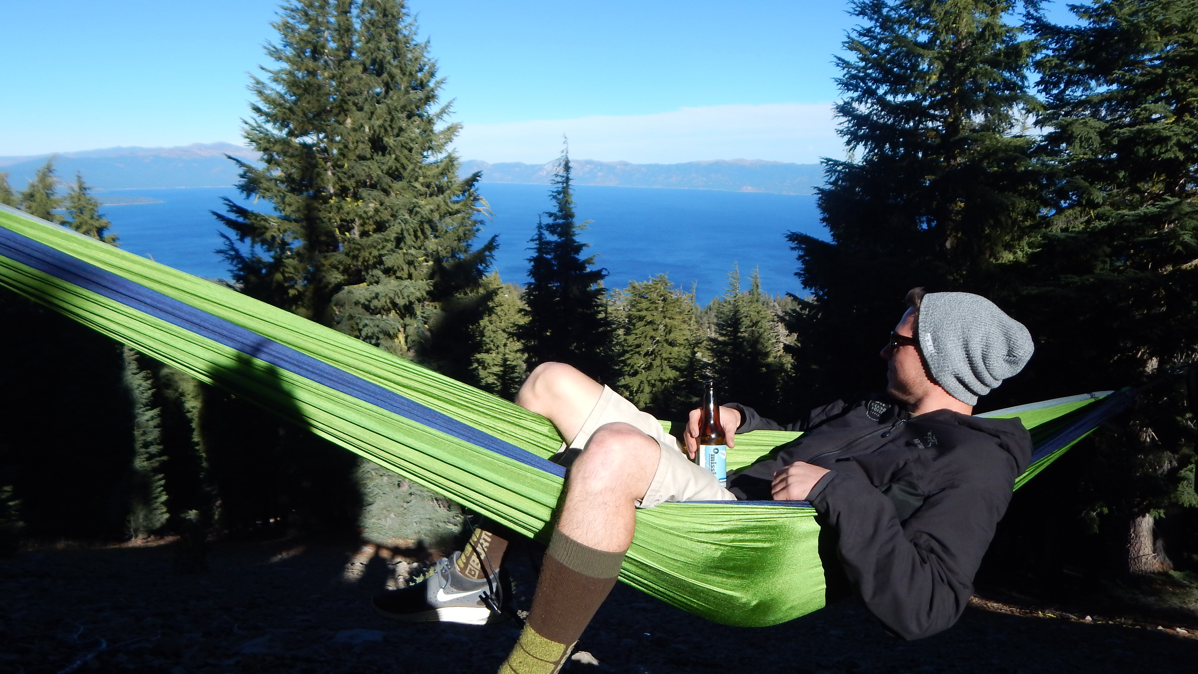


As the wind was a bit chilly on the peak, we walked down the slope that was sheltered from the wind and found a spot to hang up the hammock and make some lunch. We shared joy about how awesome this was. There is a certain pride that comes with witnessing an idea blossom into an action, and sitting atop the mountain we were happy indeed. We then struck up a conversation about what we envisioned for ourselves in the future. One of the elements we shared in our vision was that we intended to have a plentitude of experiences. We both recognised this as one of the true riches in life. [this topic will be expanded upon in a later post]
Seeing that the sun was pointing towards the west, this meant we had around 90 minutes or so before night fall. We began to head back. We came along a trail alternate from the way we originally came, but it appeared to go in the same direction so we followed it. 20 minutes into the walk though it was evident that this did not lead to where we wanted to go. The sky was beginning to change to a shade of amber. Time was slipping.. We stopped and analysed our options:
A. We could walk back 20 minutes and try to find the other trail, or
B. Walk of trail and head in a direction where we would hope to intersect the correct trail.
What would you choose?
We choose B. We walked off path and headed through a grassy field that appeared to have once had a river flowing through it. We got to the forest line and began to walk up the hill. Every so many feet we would think we recognised something, but no joy. On we kept walking. The light was beginning to fade more now under the trees. This would be a time for concern, but my friend and I were largely unfazed, it’d all work out.
After what seemed a long time though, we walked around a big tree and there it was, the path. We walked fast now to utilise the remaining sunlight. Even though that night was set to be the full moon, it wasn’t in the sky yet so we couldn’t count on it for illumination.

We were now back on the ridge top in the open air. Matt looked over his shoulder and I could see that he was visibly cold. I myself, couldn’t feel my fingers and my toes were beginning to board the train to numbville as well. I was shivering by the time we made it to the tree line and our last descent back to the car.
Reaching the car, we warmed ourselves up, drove to town to get some food. Then we set out destined for Big Surr.
To be continued..

October 31, 2015 at 12:03 pm
Grantley!
You did a really good job at telling this story. Makes me want to be out there walking through the sunset. Human Google?! hahaha bess!
Sweet sunset picture on the ridge.
Looking forward to all of the future posts!
Travel well my friend.
Rushell
LikeLiked by 1 person
October 31, 2015 at 4:03 pm
I read that with a smile on my face beginning to end. Love it. I can’t wait til the next one.
LikeLiked by 1 person
October 31, 2015 at 11:26 pm
Grantley this is my kinda excursion. I’m not a planner either, I follow my caprice every place it takes me. Awaiting part 2
LikeLike